


介绍 New Zealand Topo Maps
Easy to use outdoor navigation app with most recent topographic maps of New Zealand, Cook Islands and Tokelau.
This app gives you similar mapping options as you might know from Garmin or Magellan GPS handhelds.
*** Updated Topo50 maps to 2017 Edition ! ***
*** This Free version needs internet connection. Buy Pro version for offline usage ***
Main features for outdoor-navigation:
• Create and edit Waypoints
• GoTo-Waypoint-Navigation
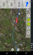
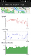
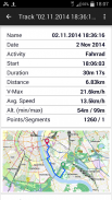
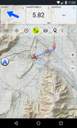
• Track Recording (with speed, elevation and accuracy profile)
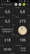
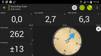
• Tripmaster with fields for odometer, average speed, bearing, elevation, etc.
• GPX-Import / Export, KML-Export
• Search (placenames, POIs, streets)
• Customizable datafields in Map View and Tripmaster (e.g. Speed, Distance, Compass, ...)
• Share Waypoints, Tracks or Routes (via eMail, Facebook, ..)
• Use Coordinates in UTM, WGS84 or MGRS
• and many more ...
Available base map layers:
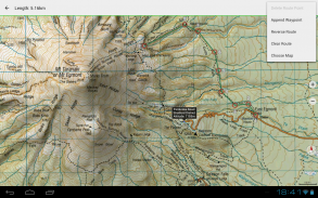
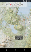
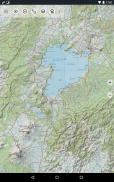
• Topomaps New Zealand (seamless coverage at scales 1:250.000 and 1:50.000)
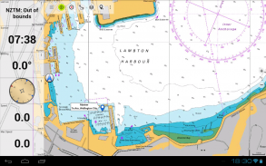
• NZMariner (RNC Nautical Charts)
• LINZ Aerial Imagery
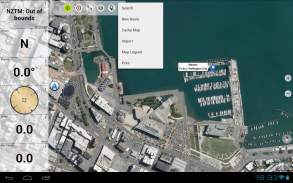
• Google Maps (Satellite images, Road- and Terrain-Map)
• Open Street Maps
• Bing Maps
• ESRI Maps
Overlay layers:
• Public Conservation Areas
• Open Hunting Areas
• DOC Camp Sites
• DOC Freedom Camping Restrictions
• DOC Huts
• DOC TRacks
• Taupo Trout Fishing District
• Hillshading
Use this navigation app for outdoor activities like hiking, biking, camping, climbing, riding, skiing, canoeing or offroad 4WD tours.
Preload FREE map data for areas without cell service. (Pro version only)
LIMITATIONS OF THE FREE VERSION:
• Ads
• Max. 3 Waypoints
• Max. 3 Tracks
• No Routes
• No import of waypoints and tracks
• No Bulkdownload
• No Local City DB (Offline Search)
The topographic maps were created by Land Information New Zealand (LINZ).
Topo50 is the official topographic map series used by New Zealand emergency services.
How topographic information is used
Defence planning: New Zealand's defence forces use topographic information for planning military exercises and swapping information with international partners.
Location and routing: Search and Rescue, defence, ambulance, fire service, police and civil defence agencies use topographic information in a wide range of planning and operational situations, from natural disasters to community policing. Usage may involve mobile/field and control room situations, and the combination of topographic information with other data.
Land management: Topographic information is used by local government for regional planning and operations, and by power, gas and telecommunications companies.
In addition, LINZ maps are used for a great variety of purposes by businesses and government departments such as the Department of Conservation, and by recreational users such as trampers and tourists.
All topographic maps have additional labels for better readability at higher zoom scales. Maps are rendered with Atlogis® hillshading to enhance topography.
Topo Map Coverage:
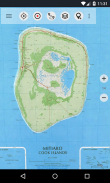
New Zealand and Islands (Antipodes, Auckland, Bounty, Campbell, Chatham, Kermadec, Raoul, Snares and Stewart Islands) at scale 1:50.000 and 1:250.000
Cook Islands (Aitutaki, Atiu, Mangaia, Manihiki, Mauke, Mitiaro, Palmerston, Penrhyn, Pukapuka, Rakahanga, Rarotonga, Suwarrow, Takute) at scale 1:25.000
Tokelau Islands (Atafu, Nukunonu, Fakaofo) at scale 1:25.000
Please send comments and feature requests to nzmaps@atlogis.com
易于使用与最近的新西兰,库克群岛和托克劳的地形图的户外导航应用。
这个应用程序为您提供了类似的映射选项,你可以从Garmin或麦哲伦GPS手持机知道。
***更新Topo50映射至2017年版! ***
***这个免费版本需要互联网连接。购买Pro版本供脱机使用***
户外导航产品主要特点:
•创建和编辑路标
•转到航路点,导航
•轨录音(有速度,高度和准确的个人资料)
•孙行者与里程表领域,平均速度,轴承,海拔等。
•GPX导入/导出,KML的出口
•搜索(地名,兴趣点,街道)
•在地图视图和孙行者定制的数据域(如速度,距离,指南针...)
•共享航点,跟踪或路由(通过电子邮件,脸谱,..)
•使用坐标在UTM,WGS84或MGRS
• 还有很多 ...
可用的基本地图的层:
•Topomaps新西兰(无缝覆盖的规模1:250.000和1:50000)
•NZMariner(RNC海图)
•LINZ航拍图像
•谷歌地图(卫星图象,道 - 和地形图)
•开放街道地图
•Bing地图
•ESRI地图
覆盖层:
•公共保护区
•开放式狩猎区
•DOC营地
•DOC自由露营的限制
•DOC小屋
•DOC轨道
•陶波鳟鱼垂钓区
•晕渲
使用适合户外活动,如远足,骑自行车,露营,攀岩,骑马,滑雪,划独木舟或越野四驱车之旅该导航应用。
预紧为区域提供免费的地图数据,而无需电池服务。 (仅Pro版)
免费版的限制:
•广告
•马克斯。 3个航点
•马克斯。 3个曲目
•无路线
•航点和轨迹的无进口
•无Bulkdownload
•没有本地城市DB(离线搜索)
该地形图是由新西兰土地信息进行(Linz)创建的。
Topo50是新西兰紧急服务所使用的官方地形图系列。
如何地形信息用于
国防部计划:新西兰国防军使用计划的军事演习,并与国际合作伙伴交换信息的地形信息。
位置和路由:搜索和救援,国防,救护,消防,警察和民防机构在广泛的规划和运营的情况下使用地形信息,从自然灾害到社区治安。使用可涉及移动/场和控制室的情况下,以及与其他数据地形信息的组合。
土地管理:地形信息由当地政府对区域规划和运营,并通过电力,天然气和电信公司。
此外,林茨地图用于企业和政府部门,如环境保护部,一个伟大的多种用途和娱乐用户如trampers和游客。
所有地形图在更高的变焦倍数有更好的可读性附加标签。地图呈现与Atlogis®山体阴影,以增强地形。
地形地图覆盖范围:
新西兰和规模1群岛(拓地,奥克兰,赏金,坎贝尔,查塔姆,克马德克,劳尔,圈套和斯图尔特岛):50000和1:250.000
库克群岛(艾图塔基,阿蒂乌,曼加伊亚,马尼西基,毛凯,米蒂亚罗,帕默斯顿,彭林,普卡普卡,Rakahanga,拉罗汤加,Suwarrow,Takute)在比例1:25.000
托克劳群岛(阿塔福,努库诺努,法考福)在比例1:25.000
请发送意见和功能要求nzmaps@atlogis.com
New Zealand Topo Maps - 版本7.2.0
(19-01-2024)New Zealand Topo Maps - APK信息
APK版本: 7.2.0程序包: com.atlogis.nzmaps.free同类应用
您可能还会喜欢……


